|
||||
|
||||

|
Space pictures of Nepal, Tibet and the Himalaya
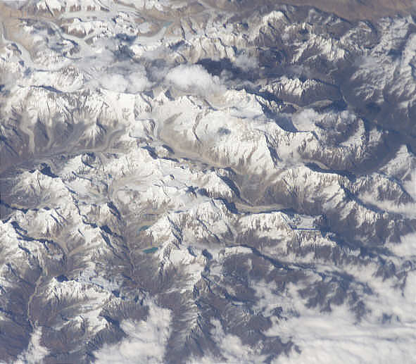
Space picture of Mera Peak and the Ice Col Route
Credit "Image courtesy of Earth Sciences and Image Analysis Laboratory, NASA Johnson Space Center." See http://eol.jsc.nasa.gov , Part of Picture ISS008-E-6639, Adaption Andrées de Ruiter www.nepal-dia.de The Ice Col Route The ice col route is the highest trekking route. It is a high alpine expedition . It is stating in the Barun valley and leads over the Sherpani col ( 6110) , West Col 6135 into the hunku valley ( Which you also can reach coming from Mera peak). going to panch pokhari you descent the difficult Amphu Lapts la into the Khumbu Valley. It will take you 9-12 days in high altitude and about 10 days to reach the starting point.
Credit "Image courtesy of Earth Sciences and Image Analysis Laboratory, NASA Johnson Space Center." See http://eol .jsc.nasa.gov , Part of Picture ISS008-E-6639, Adaption Andrées de Ruiter www.nepal-dia.de See the excellent Pictorial : Mera, Island & Khumbu Circuit by David Wong . A great picture slideshow showing an expedition to Mera peak and the way from there to Khumbu by the Amphu Laptsa The mistery of the real Merapeak. There is some confusion about which mountain should be named Mera peak. Read more about The real mera peak, false mera peak and peak 41
Back to the overview Space Pictures of Nepal
These pictures are kindly provided by the Nasa Johnson space center and you can download free more than 40000 of them. I myself made the selection, some adaptions and added names. Feel free to add them to your own hompage, but please add the credit as mentioned below of each picture.
|
||||||